Introduction

Mumbai ,formerly known as Bombay, is the capital of the Indian state of Maharashtra. With an estimated population of 20.5 million, it is the largest metropolis in India and one of the most populous cities in the world. The Mumbai Metropolitan Area which includes cities of Navi Mumbai & Thane, is also the world's 5th most populated metropolitan area.

There are so many Places around Mumbai to see . Which include Temples, Historical Places, Hill station, Wild Life and Waterfalls etc.
This site help to find out known-unknown places around Mumbai. which can be one or two day picnic for People and children's who don't have time.
Then What you are Thinking Lets Plan to see Nature..
Showing posts with label Nature. Show all posts

Saturday, August 30, 2014

Peb Fort (Vikatgad)


Peb Fort Height : 2100 ft
Peb Fort Type : Hill
Base Village: Neral 
District : Raigad

Trekking near Mumbai to Peb Fort or Vikatgad around 4 km from Neral Station a very enjoyable trek in Monsoon season passing through a local village, waterfalls this trek offers all ladders, rock patches, caves, dense forest, ridge walking. Trek can be combined with Matheran visit or you can trek till Panorama point Matheran till here. Excellent for new trekkers a village guide or guided tour will make the trek more enjoyable.


Peb Fort History :
It is assumed that this fort derived its name Peb from the 'Goddess Pebi' at the base of the fort. Historical references clearly indicate that Shivaji Maharaj used the caves on the fort as silos for grain storage.

The cave on the fort is occupied by disciples of Swami Samarth, a great saint. They have contributed a lot to development on this fort from last ten years. They have managed successfully to keep the cave and the fort clean, and maintained the dignity of the fort. Near to this cave are meditation caverns, which are underground. These caverns are still in good condition. One has to crawl into these and only one man can enter at one time. In monsoon two of these are filled with water. On the top we can go by climbing the wall of the fort. On the top we can see some remnants. The main attraction here is the bastion on the topmost part. This faces the mountain of Matheran. Here we can clearly see the ridge connecting mountains of Matheran and Peb. When we stand here we feel to be at the top of the world.

On the other side of the fort is a temple of a deity. Here is a big cistern. The disciples are constructing a good temple here. We can reside here for some time.The beautiful waterfall on the way is the main attraction here. Surrounding scenery looks marvelous from the cave in the monsoon. From here we also see the pinnacles of Navara-Navari, Bhatoba and Irshaal, along with forts of Chanderi, Prabalgad and Malanggad and also Nakhind. This trekking is pleasant in all seasons.


How to reach : Peb Fort or Vikatgad

By Train from Neral station :

• Alight at Neral Railway Station (Central Railway Route)
• Walk pass ticket booking center and take right.
• Walk towards Matheran Taxi stand keep walking till main road
• After reaching main road left goes to Matheran
• Cross the road and keep walking straight.
• Some houses under construction could be used as landmarks on the way.
• Proceed towards the huge electric towers on the way near 2nd electric tower we see a big waterfall.
• Trek path starts from here Base Village Anandwadi - Fanaswadi
• You can hire a guide from village it takes 3 hours to complete this trek
• Please carry water and food along with you
• From Matheran Panorama point a way to Peb is available you can reach the cave within 6 hours carving of eagle is seen at the base of cave.
Peb Fort Stay:
A small cavern is available which can accommodate 10 people max


Monday, August 25, 2014

Prabalgad


Brief Details of the fort:

Height above mean sea level: 707 metres / 2320 feet.

Grade: Medium
Base Village: Thakurwadi
Trekking Area: Panvel.
Best time: During Rainy season or after rainy season

Trekking Routes: 
There are many routes to this fort. The route to and fro - Thakurwadi village near panvel


History: There is not much mention of this fort in history. However in 1658, Shivaji conquered Prabalgad from the Mughals, after establishing his powers in the Kalyan-Bhiwandi area. When Shivaji attacked the fort, the Mughal Sardar and fort chief Kesar Singh forced himself and the ladies in the fort to commit suicide so as to save themselves from falling into the hands of the Marathas. His mother along with her grandchild hide inside the fort by the fear of Shivaji, but such was the greatness of Shivaji that on finding them he sent them to their village with genuine respect and dignity.


Tikona fort

Basic Info: Tikona fort is a hill fort located near Kamshet [Maval region] in Maharashtra. Height from sea level is 3500 feet. Its twin fort is called Tung.
Routes: First you would have to head towards Lonavala and from Lonavala to Kamshet. Then from Kamshet the locals can guide you for the route to Gavhande Village which is also called as Tikona Peth. This is the base village for Tikona. From this point the actual trek begins.


Difficulty Level and Other useful tips: 

Difficulty level is Easy. Takes 1 1/2 hours to reac to the top of the fort.
Some parts are almost vertical as the fort is triangular in shape.

Ideal Time for Tikona Trek: During the winter season or rainy season.
Camping Info: 

Not ideal for camping, but incase you plan for camping, there is a cave which you can use as sheter during night time. Carry plenty of water and firewood.

What to see on the fort:

   Big Entrance Door
   Trimbakeshwar temple
    Caves
   Lake surrounding the fort


Kalavantin Durg

This fort is just opposite to Prabalgad. It is also visible from Mumbai-Pune highway. According to stories, the fort was built for a queen named Kalavanti. Steps leading up to the fort have been cut into the rock face of the hill. From the peak of this fort you can see a 360⁰ panoramic view of Matheran, Chanderi, Peb, Ershal, and Karnala forts, and also the Mumbai city. The Adivasi People of Machi-Prabal village observe the custom of dancing on every Holi (Shimga) Festival at the top of Kalavantin fort. These people have a long-standing relationship with this fort and it has become a part of their heritage.


How to get there:
Panvel railway station 
Reach the state transport depot or hire an share autorickshaw till Thakurwadi village 

You can also get down at shedung phata an take an rickshaw till thakurvadi 

Kalavantin Height: 500 meters or 2300 ft

Kalavantin Difficulty: Medium


Food Arrangement - Some options are available at Prabal Machi though its best to carry lunch.
Kalavantin Best Time to Visit: Can be visited all year round.

Kanheri Caves

One of the airiest places in the city, the Kanheri Caves premises offers a pleasant break from the pollution and the noisy, metropolitan life. Nestled in the Sanjay Gandhi National Park at Borivali, the Kanheri Caves are also known as the 'lungs of Mumbai', because this is the only place in the city with the maximum amount of greenery and consequently, a lot of fresh air. The caves date back to 1st century BC and are believed to be one of the oldest cave formations of the country. The Kanheri Caves are renowned for their natural Basalt formations, ancient Indian styled architecture and the 109 special entrances to the caves. The word Kanheri originates from the Sanskrit term 'Krishnagiri'. Each cave here, unlike the other caves in the country, is adorned with a 'splinth' or a rock bed. Congregation halls with large stupas also indicate that the caves were Buddhist shrines and a focal point during the Buddhist settlement in the 3rd century. The Kanheri Caves became a distinctive Buddhist institution for congregational worship, study and meditation.


A Cluster Of Rock Cut Monuments 
When one visits the Kanheri Caves, there is a lot to see, in terms of what the caves have to offer and even around the caves. There are about 34 unfinished paintings of Buddha within the Caves. Apart from the paintings, one should also visit the 'Vihara' (prayer hall) and the different monasteries around the cave for a glimpse of former Buddhist occupation and life. If you have had enough of history and you are looking for a bit of excitement, then planned tours, adventure sports such as rappelling/trapeze and treks around Sanjay Gandhi National Park or the Silondha Trail can also be arranged by local tourist guides. The hilly terrain of the caves also creates several, small waterfalls which are beautiful to see. Natural streams and rivers around the Kanheri Caves offer stunning views and beautiful locations for families to enjoy a small picnic while visiting the caves.

Eating Out
There are a number of local eateries outside the Sanjay Gandhi National Park. Restaurants such as Greens Veg Restaurant, Cascade, Bay View Restaurant and Aura Restaurant that offer the best of local cuisine. Local food vendor's can be found right outside the national park, selling nuts, juices, cotton candies, freshly baked crisps and the local Chaats.

How To Reach 
By Road 
The Kanheri Caves, situated within Sanjay Gandhi National Park, are located in the heart of Mumbai. You can reach this place with local transport (auto-rickshaws, taxis and local buses). Once at the national park, you can either decide to trek to the Kanheri Caves or opt for paid transport within the park.

By Rail 
The Borivali and Malad stations are the closest disembarkation points if you want to get to the Kanheri Caves. From here, you can opt or local transport to take you the Kanheri Caves.

The Kanheri Caves are one of the most popular tourist destinations in Mumbai. Apart from the caves, feel free to explore the Sanjay Gandhi National Park, but with supervision and permission from the local authorities. The caves offer tourists and picnickers a perfect getaway and transport visitors into a historical world that once flourished.

Sunday, August 24, 2014

Lohagarh Visapur Fort


With a 2000 year old history and at 3400 ft high, Lohagad one of the magestic forts in the region. The climb to the fort takes you to panoramic vantage points, huge balconies, doors and reminds you how important this place was which was used to defend freedom. Surrounded by lakes on all side the views from the fort are breathtaking specially from vinchu kata (Scorpion's tail).

Brief Info about Lohagad Fort:
This fort is 10km from Lonavala (100 Kms from Mumbai and 60 Kms from Pune). It belongs to the period of Chattrapati Shivaji's reign and was used for keeping prisoners in the year 1564.

In 1670, Shivaji Maharaj won this fort and in the year 1751, Gaikwad and Dabhade family were incarcerated in this fort. The entrance to this fort is impressive and is aptly called 'Delhi Gate'. There are three gates one after the other.

How To Reach: 
Train or Road:
Alight at malavli station which is the next station after lonavala. Lonavala is midway between mumbai and pune. Cross the mumbai pune express highway via overhead bridge and turn walking towards mumbai direction to bhaje village which is approx 2 Kms. From bhaje walk towards lohagad. After a gruelling but scenic trek of about 2 and half hours (7 KMS) you reach the foothills of the fort. The small village there houses couple of small hotels. It can be a pretty hectic trek for 1 day if you don't have your own vehicle. Take plenty of water in summers(Feb to June). Best time to visit is between July and December.


Nearby attractions :
Visapur Fort
Bhaja Caves - 2 km (1.2 mi) from Malavli, once home to Buddhist monks.
Karla Caves
Lonavala - 20 km (12 mi), a famous and scenic hill station.
Aamby Valley City - 22 km (14 mi) from Lonavala.


For more pics Click Here

Saturday, August 23, 2014

Harishchandragad


ABOUT HARISHCHANDRAGAD


Harishchandragad is one of the best trekking spot in the Sahyadris of Maharashtra. It can be rated 8 in the scale of 1-10 with 10 being the highest. A trek to Harishchandragad is a must for trekking lovers.

HISTORY OF HARISHCHANDRAGAD


Harishchandragad is one of the oldest leading forts in the Sahyadris. The existence of Microlithic man has been discovered here. The fort is estimated to be built during the reign of Kalchuri and references about Harishchandragad can be found in various manuscripts like Skandapurana & Matsyapurana. It is said that the great sage Changdev used to meditate in the caves present here in the 14th century. 

Idols of Lord Vishnu which are carved in the 11th century are found in the caves beside the temple of Harishchandreshwar. The carvings in the Harishchandreshwar temple and in Kedareshwar cave denote that the fort belongs to medieval period. The fort has played a major role in guarding the Malshej Ghat region and the surrounding areas. Later, the fort was captured by Moghuls which was then captured by the Marathas in 1747.


General Information


RegionMalshej ghat
District: Ahmednagar
RangeHarishchandragad
Height: 4671 feet
Grade: Moderate/Difficult (depending on the chosen route)


ROUTES TO HARISHCHANDRAGAD


Harishchandragad is accessible from Thane, Pune and Ahmednagar. Harishchandragad Fort can be reached via various routes from different places.  Below are the travel routes from different cities.

HARISHCHANDRAGAD FROM MUMBAI

1) Khireshwar (Tolar Khind, Rajmarga)

Mumbai - Kalyan - Khubi phata- Khireshwar

1. Catch a local going towards Kalyan (on Central Line). Get down at Kalyan Station.

2. The ST depot is just besides the station on the west side. Catch any ST going towards Alephata (strictly going via Malshej Ghat)

3. Ask the ST conductor for a ticket of Khubi Phata. Khubi Phata is just 5 mins after the Malshej Ghat ends.

4. Get down at Khubi Phata and start walking on the 6 km long dam that just starts besides the road.

5. Lucky you, if you get a jeep or something, or just keep walking (a good warmup :p ) Once you reach the base village Khireshwar, the actual trek for Harishchandragad starts !!!

2) Belpada (Nalichi vaat, Rajmarga, Sadhleghat)

Mumbai - Kalyan - Savarne- Belpada

Mind it, this is a very tough route and not at all recommended for freshers !
1. Follow the previous (via Khireshwar) instructions till point number 2.
2. Ask the ST conductor for a ticket of Savarne. Savarne comes just before the start of Malshej Ghat.
3. The straight 1 hour walk from Savarne takes you to the base village Belpada (now Walivare)
4. From Belpada, the trek to Harishchandragad via Nalichi vaat or Rajmarga or Sadhleghat begins !!


HARISHCHANDRAGAD FROM PUNE

1) Catch an ST from Pune towards Alephata.
2) Get down at Alephata & catch another ST moving for Kalyan (strictly going via Malshej Ghat).
3) To trek Harishchandragad via Tolar Khind (Khireshwar), get down at Khubi Phata. Khubi Phata comes just before the Malshej Ghat.
4) To thek Harishchandragad via Nalchi Vaat, Rajmarga or Sadhleghat, get down at Savarne. Savarne arrives just after the end of Malshej Ghat

Below is the brief description, easy to understand
Pune - Ale phata - Khubi phata - Khireshwar
Pune - Ale phata - Savarne - Belpada

HARISHCHANDRAGAD FROM PACHNAI


One has to board the bus for Nasik or Mumbai & alight at Ghoti village. From Ghoti, we have to board another bus to Sangamner via Malegaon & alight at Rajur village. From here, 2 ways diverge to the fort.
1) From Rajur, one has to board the bus or a private vehicle to the village of Pachanai. From here, the way is straight to the topmost point.
2) Recently, the way from Rajur to Tolar Khind has been made available. From Tolar Khind (Tolar valley), the temple is about 2-3 hours by walking.

Reaching Pachnai from Mumbai is fairly difficult as one has to change several buses and loses a lot of time in transit. If one is approaching from Pune/ Nashik, one can reach Pachnai from either Rajur, Kotul, Akole or Sangamner.

Following are the five trek routes to Harishchandragad

Route 1: Tolar Khind

After getting down at Khubi phata, one has to take a 4-5 km walk on the wall of the dam called Khireshwar dam. The dam ends at Khireshwar village, and from here onwards a straight route trail goes towards Tolar khind.Around 2-2.5 hours are required to reach till Tolar khind from Khireshwar village. The end of the khind has a stone carving of a lion, symbolising that it is protecting the pass. After the khind, is a 100 feet rock patch, which has iron railings for the safety of trekkers. There is no need for any kind of special trekking gear at all like ropes, etc to climb it. The climb on the rock patch then leads a straight way to Harishchandreshwar temple, with small hills & streams in between.

Route 2: Nalichi Vaat

Nalichi vaat is the most difficult route to Harishchandragad. One has to start from the Belpada village and begin the climb parallel to the huge Konkan Kada. To the left of Konkan Kada are 3-4 channels that come down from the top. The channel to the extreme right is the Nalichi vaat. 

Nalichi vaat is a tricky route having a 80 degree ascents at some points and the toughest rock patches. Here, trekking gear is required to ascend the rock patches as sometimes there is no slit available for having a grip. Hence, route is recommended strictly for the experienced trekkers.

Route 3 : Rajmarga

Rajmarga, which is currently in bad condition, was the main route to ascend Harishchandragad a long back. This route follows the same path till Khireshwar village. From here, instead of following the way to Tolar Khind,one must go along the straight path and start ascending on the slopes of Kalshya dongar (ask any villager for the route to Kalshya dongar). The cliff that comes after the Kalshya dongar has to be ascended. The climb has rock crumbling and lot of scree with dangerous patches in between. After this tricky ascent, one joins the Tolar khind route after the rock patch.

Route 4: Sadle Ghat

Sadhle ghat is a steep descent from the fort down to the base. To approach Harishchandragad via this route, one has to walk straight to Kelewadi from Belpada instead of going towards Konkan Kada. From Kelewadi village onwards, an ascend via the steep slope of Sadhle Ghat brings you on the top. It is best to descend from Harishchandragad via Sadhle Ghat instead of ascending it.

Route 5: Pachnai

Pachnai is the simplest route to Harishchandragad and absolutely recommended for anyone of any age. From the Pachnai village, it takes around 2.5-3 hours to reach Harishchandragad. A guide is available at the Pachnai village if required.

FASCINATING SPOTS


Saptatirtha Pushkarni 

Saptatirtha Pushkarni

A pond named Saptatirtha Pushkarni is present on the eastern side of the temple. On its bank are 14 temple-like constructions in which there are idols of Lord Vishnu. However, these idols are now shifted in the caves besides Harishchandreshwar temple. Some stupid and irresponsible trekkers are making this pond untidy by throwing plastic waste and other stuff. A few years back the water was potable, and now you can't even think of swimming in it. 


Kedareshwar Cave 
Kedareshwar Cave

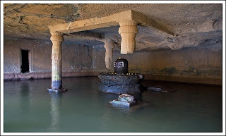
Moving parallely along the temple, just a few steps after it lies a huge cave known as the Kedareshwar cave. Inside the cave is a big Shivlinga, of about 5 feet tall, which is completely surrounded by water. A huge stream of water flows outside the cave during monsoons, which hardly makes it possible to enter the cave. Moreover, the water in the cave is ice cold ! 


Harishchandreshwar Temple

Harishchandreshwar Temple

The temple is an excellent structure made out of sculpture carving and depicts the medieval period temples of ancient India. The temple is arount 16 meters high from its base. This temple has got a few caves and water tanks surrounding it. A river called Mangal Ganga is said to originate from one of these water tanks. There are three main caves near the temple. The cisterns near the temple provide drinking water. A short distance away, another temple called Kashitirtha is located. The fascinating thing about this temple is that it has been carved out from a single huge rock. There are entrances from all the four sides. These are faces of guards of the temple. On the left side of the entrance is a Devnagri inscription, which is about saint Changdev.


Konkan Kada (Konkan cliff) 

Konkan Kada

Well, this is an interesting spot for which most of the trekkers come here. This cliff faces towards west and looks down on Konkan. The Konkan Kada is approximately 4000 m in height. It is an overhang, like a cobra's hood. When there is little fog in the valley, and the sun is behind the person facing the valley, a circular rainbow can be seen. One phenomenon that can be observed at this place is the vertical cloud burst, in which the clouds nearing the cliff get sucked into the pit fall area below are thrown vertically into the sky reaching more than 50 feet (15 m). It creates a magical wall that is rising straight from the edge of the cliff without entering the landmass area.


Taramati Peak  

Rohidas & Taramati peak as seen from Malshej Ghat

Being the second highest peak in Maharashtra,Ttis is the topest point on the fort (1429 m), and is also known as Taramanchi. From this peak, many of the surrounding forts like Naneghat, Siddhagad, Ajoba, Kulang fort can be seen. Many people have seen leapords in the jungle beyond this peak.


FOOD AND STAY

A few villagers at the top of the fort make the food arrangements. The meal includes bhakri, bhaaji, daal, bhat, etc. along  with snacks such as kanda bhaji, pohe, tea, etc. They stay in a couple of caves near Harishchandreswar temple.

Bhaskar Badad: 8308081939 / 8605986514 (get in touch with him if you are looking for a guide to trek via Nalichi vaat, he has got all the required trekking gear, also makes food and tent arrangements at the top)


Tuesday, August 19, 2014

Kalsubai - Highest peak in the Sahyadris in Maharashtra

trek to Kalsubai 

Kalsubai Peak (Marathi: कळसूबाई शिखर) is the highest peak (1646 meters / 5400 feet) of the Sahyadris in Akole Taluka, of Ahmednagar district of Maharashtra, an Indian state. It is situated on Kalsubai mountain range which is an offshoot range from main sahyadri range and rung from west to east.

This entire range is amazing from the trekking point of view. Though small in length, this range has some of the tallest peaks and toughest forts. Starting from west to east this range contains Kulang, Madan, Alang forts. Top of Kalsubai peak gives and excellent view of all these forts.

Kalsubai, though a highest peak, from trekking point of view its easy. the peak has a temple and to visit this temple many people trek to the top. So for sake of such pilgrim trekkers government and local villagers has made the route easy and safe by putting ladders and staircase wherever necessary. So reaching to the top is just a test of your stamina and not mountaineering skill. But once you reach the top then you get absolutely uninterrupted view of surrounding. No other peak pokes its nose between you and the spectacular view.

The month of October, little bit hotter than monsoon or winter is excellent for this trek. Since monsoon is over you can enjoy the clear skies and hence get excellent view and on other hand soil is still moist and so you get to see receding but excellent flowering all over the route. November onwards this treks becomes dry and in monsoon its too much rainy.


The main route to the temple is at small climbing slope. It usually takes three  to four hours to reach the top from Bari. Soon after leaving Bari, There are three iron ladders along this route. There is a well near the last iron ladder as one approaches the top but the water is not potable during the summer. The rest of the route is without water, so it is best to fill water bottles in Bari. It is an easy hike, but parts of it are quite steep in places.

The vastly spread out backwaters of Bhandardara attracts ones attention from the top. To the north of the mountain range forts such as Ramsej, Harihargad, Brahmagiri, Anjaneri, Ghargad, Bahula, Tringalwadi, Kavnai can be seen. To the east one can spot Aundha, Vishramgad, Bitangad, to the west Alang, Madangad, Kulang, Ratangad (south west) and to the south Pabhargad, Ghanchakkar, Harishchandragad can be seen. Randha waterfall can be visited during this trek .


kalsubai map

Location :- Akole Taluka, of Ahmednagar district of Maharashtra
Base village:-  Bari Village ( 40 kms from Igatpuri Railway station by State Transport (ST) )
Difficulty level:- Easy

How To Reach

To start point: from Igatpuri to Bari Village, it is 40 km/2 hours by the Bhandardara State Transport (ST) by bus. 
All ST buses stop at Bari Village (about 12 km before Bhandardara); you can get off here.

A better option is to catch a bus/jeep to Ghoti, which is 7km away and get a jeep from there to Bari. 

To Hub: from Mumbai, take NH3 to Igatpuri over the Kasara Ghat, via Senapati Bapat Marg (Tulsi Pipe Road) Bus stand in Mumbai to Nasik via Igatpuri.


Best Time
During rainy season or after rainy season

Where to Stay
This trek can be done in one day

Where to eat
Bari Village 


For more pics Click Here


Friday, February 8, 2008

Kondeshwar (Badlapur)


FOR MORE PHOTOS(New Pics) CLICK HEREKondeshwar ,It is 20 kms from Badlapur. It is a 4 00 year old Temple of Lord Shiva called Kondeshwar, a place where many people visit Kondeshwar has a beautiful water fall along with a pond. There is a temple of Lord Shiva and hence the name Kondeshwar. Kondeshwar is remotely located away from noise and urban pollution, with the nearest village located about 20/25 minutes by walk.


Though Kondeshwar is a very beautiful place to be in a monsoon period, there have been many accidents and fatalities due to unsafe swimming practices by people who have very less Knowledge of the crevices under the water.


Many people have died due to the turbulence of the waterfall and they were taken inside the crevices from where it is very difficult to come out due to the heavy force of water.